Introduction:
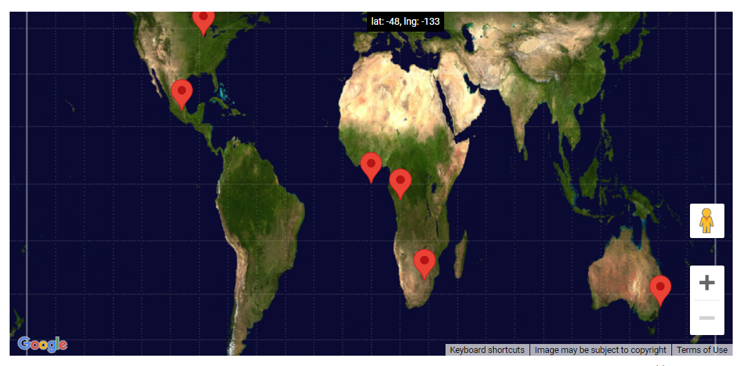
In this tutorial, we will learn with an example create a map using the Gall-Peters projection, rather than the default Mercator projection.
The Earth is a three-dimensional spherical (roughly), whereas a map is a two-dimensional flat surface. The Maps JavaScript API map, like every flat map of the Earth, is a projection of that sphere onto a flat surface. In its most basic form, a projection is a mapping of latitude/longitude values onto coordinates on the projection’s map.
Maps JavaScript API projections must implement the Projection interface. A Projection implementation must provide bi-directional mapping as well as a mapping from one coordinate system to another. That is, you must describe how to convert from Earth coordinates (LatLng objects) to the world coordinate system of the Projection class, and vice versa. Google Maps creates maps from geographic data using the Mercator projection and converts map events into geographic coordinates. This projection may be obtained by executing getProjection() on the Map (or any of the standard base MapType types.) This standard Projection will suffice for most purposes, but you can also define and use your own custom projections.
Code:
// This example defines an image map type using the Gall-Peters
// projection.
// https://en.wikipedia.org/wiki/Gall%E2%80%93Peters_projection

function initMap(): void {
  // Create a map. Use the Gall-Peters map type.
  const map = new google.maps.Map(
    document.getElementById("map") as HTMLElement,
    {
      zoom: 0,
      center: { lat: 0, lng: 0 },
      mapTypeControl: false,
    }
  );

  initGallPeters();
  map.mapTypes.set("gallPeters", gallPetersMapType);
  map.setMapTypeId("gallPeters");

  // Show the lat and lng under the mouse cursor.
  const coordsDiv = document.getElementById("coords") as HTMLElement;

  map.controls[google.maps.ControlPosition.TOP_CENTER].push(coordsDiv);
  map.addListener("mousemove", (event: google.maps.MapMouseEvent) => {
    coordsDiv.textContent =
      "lat: " +
      Math.round(event.latLng!.lat()) +
      ", " +
      "lng: " +
      Math.round(event.latLng!.lng());
  });

  // Add some markers to the map.
  map.data.setStyle((feature) => {
    return {
      title: feature.getProperty("name"),
      optimized: false,
    };
  });
  map.data.addGeoJson(cities);
}

let gallPetersMapType;

function initGallPeters() {
  const GALL_PETERS_RANGE_X = 800;
  const GALL_PETERS_RANGE_Y = 512;

  // Fetch Gall-Peters tiles stored locally on our server.
  gallPetersMapType = new google.maps.ImageMapType({
    getTileUrl: function (coord, zoom) {
      const scale = 1 << zoom;

      // Wrap tiles horizontally.
      const x = ((coord.x % scale) + scale) % scale;

      // Don't wrap tiles vertically.
      const y = coord.y;

      if (y < 0 || y >= scale) return "";

      return (
        "https://developers.google.com/maps/documentation/" +
        "javascript/examples/full/images/gall-peters_" +
        zoom +
        "_" +
        x +
        "_" +
        y +
        ".png"
      );
    },
    tileSize: new google.maps.Size(GALL_PETERS_RANGE_X, GALL_PETERS_RANGE_Y),
    minZoom: 0,
    maxZoom: 1,
    name: "Gall-Peters",
  });

  // Describe the Gall-Peters projection used by these tiles.
  gallPetersMapType.projection = {
    fromLatLngToPoint: function (latLng) {
      const latRadians = (latLng.lat() * Math.PI) / 180;
      return new google.maps.Point(
        GALL_PETERS_RANGE_X * (0.5 + latLng.lng() / 360),
        GALL_PETERS_RANGE_Y * (0.5 - 0.5 * Math.sin(latRadians))
      );
    },
    fromPointToLatLng: function (point, noWrap) {
      const x = point.x / GALL_PETERS_RANGE_X;
      const y = Math.max(0, Math.min(1, point.y / GALL_PETERS_RANGE_Y));

      return new google.maps.LatLng(
        (Math.asin(1 - 2 * y) * 180) / Math.PI,
        -180 + 360 * x,
        noWrap
      );
    },
  };
}

// GeoJSON, describing the locations and names of some cities.
const cities = {
  type: "FeatureCollection",
  features: [
    {
      type: "Feature",
      geometry: { type: "Point", coordinates: [-87.65, 41.85] },
      properties: { name: "Chicago" },
    },
    {
      type: "Feature",
      geometry: { type: "Point", coordinates: [-149.9, 61.218] },
      properties: { name: "Anchorage" },
    },
    {
      type: "Feature",
      geometry: { type: "Point", coordinates: [-99.127, 19.427] },
      properties: { name: "Mexico City" },
    },
    {
      type: "Feature",
      geometry: { type: "Point", coordinates: [-0.126, 51.5] },
      properties: { name: "London" },
    },
    {
      type: "Feature",
      geometry: { type: "Point", coordinates: [28.045, -26.201] },
      properties: { name: "Johannesburg" },
    },
    {
      type: "Feature",
      geometry: { type: "Point", coordinates: [15.322, -4.325] },
      properties: { name: "Kinshasa" },
    },
    {
      type: "Feature",
      geometry: { type: "Point", coordinates: [151.207, -33.867] },
      properties: { name: "Sydney" },
    },
    {
      type: "Feature",
      geometry: { type: "Point", coordinates: [0, 0] },
      properties: { name: "0°N 0°E" },
    },
  ],
};

declare global {
  interface Window {
    initMap: () => void;
  }
}
window.initMap = initMap;
export {};
Explanation:
- The function initMap() is created and it consists of the map properties.
- The line, “map = new google.maps.Map(document.getElementById(“map”)”; creates a new map inside the <div> element with the help of the mentioned id which is ‘map’ as an HTMLElement.
const map = new google.maps.Map(
    document.getElementById("map") as HTMLElement,
center: { lat: 0, lng: 0 },
zoom: 0,
mapTypeControl: false,
initGallPeters();
  map.mapTypes.set("gallPeters", gallPetersMapType);
  map.setMapTypeId("gallPeters");
const coordsDiv = document.getElementById("coords") as HTMLElement;
map.controls[google.maps.ControlPosition.TOP_CENTER].push(coordsDiv);
map.addListener("mousemove", (event: google.maps.MapMouseEvent) => { }
 // Wrap tiles horizontally.
      const x = ((coord.x % scale) + scale) % scale;

      // Don't wrap tiles vertically.
      const y = coord.y;
window.initMap = initMap;
Conclusion:
In this tutorial, we learned about how to create a map using the Gall-Peters projections rather than the default Mercator projection.